
A couple of years back, my colleague Rania came back from a trip to Bolivia and I asked her the usual thing — how was it, was it worth it, all that. She just pulled out her phone, showed me a photo, and went quiet. Not in a dramatic way. More like she genuinely didn’t have words yet and was still processing.
The photo was of her standing on what looked like the sky. Below her feet, above her head — the same thing. White and blue and completely flat, going on forever in every direction. I kept rotating the phone thinking I was holding it wrong.
That was the Salar de Uyuni. And after she showed me that picture, I fell into a proper rabbit hole of places on this planet that genuinely look like they belong somewhere else. Places where experienced travelers go quiet. Where even people who’ve been everywhere say something like “I wasn’t ready for that.”
This is about those places. Not the usual pretty destinations with a dramatic sunset. Specifically the ones where your brain sort of glitches because nothing in your visual memory matches what you’re looking at.
The Thing About Places That Don’t Look Real
You know how you can look at a really well-done CGI scene in a film and something just feels slightly off? Like your eye can’t fully believe it even though it looks technically perfect?
Standing in certain real landscapes does the exact opposite of that. Your eye is telling you it’s real because you’re there, your feet are on the ground, you can smell the air. But your brain keeps filing a complaint because nothing about what you’re seeing matches any template it’s ever built.
That specific feeling is hard to find. Most places, even incredibly beautiful ones, fit into categories your mind already has. Mountains. Forests. Coastlines. Your brain goes “beautiful, noted” and files it away.
These places don’t get filed. They just sit there, unresolved, and that’s what makes them genuinely worth the trouble of getting to.
Salar de Uyuni, Bolivia
Let me start with the one that started all of this for me, secondhand through Rania’s phone screen.
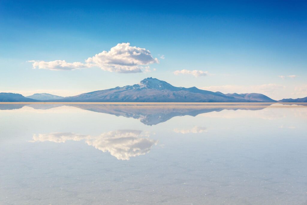
The Salar sits at about 3,600 meters in southwest Bolivia and it’s the largest salt flat on Earth. During the dry season, the surface is white salt crust broken into hexagonal patterns as far as you can physically see. Not figuratively. Literally as far as your eyes work. No trees, no hills, no buildings. The horizon is just a thin line between white ground and blue sky, and it’s so flat that the line looks painted on.
During rainy season, a few centimeters of water sit on the surface and reflect the sky so perfectly that you genuinely lose track of which direction is up. Rania said she kept having to look at her feet to confirm the ground was there. That’s not a poetic thing to say. That’s just what happens.
Actually Getting There and What Goes Wrong
The town of Uyuni is your starting point. You can reach it by overnight bus from various Bolivian cities, which sounds adventurous and is actually just uncomfortable. There’s also a short flight from La Paz if your budget allows.
The tour situation is important to understand before you book. There are dozens of operators in Uyuni and the price difference between cheap and slightly-less-cheap is significant. Cheap usually means an ancient Land Cruiser with no working heater, a driver who speaks no English and will not slow down on unsealed roads, and food stops at places that have clearly not been cleaned since the vehicle was new. This is fine if you know what you’re getting into. Less fine if you were expecting something different.
Altitude is the thing that surprises people most. La Paz itself is already high. The Salar is higher. If you fly into La Paz and immediately head south without giving your body a couple of days to adjust, there’s a reasonable chance you’ll spend your first night on the salt flat feeling genuinely terrible. Headache, nausea, no appetite, can’t sleep. Coca tea is everywhere and helps a little. Diamox works better and you can get it over the counter in Bolivia.
Nights are cold in a way that’s hard to describe unless you’ve experienced high-altitude desert cold. It’s a specific, dry, bone-settling cold that layers don’t fully solve. Pack more than you think you need.
Pamukkale, Turkey
From the road approaching it, Pamukkale looks like someone accidentally left a ski slope in the wrong country. A hillside of what appears to be snow, pure white, running all the way down to flat land below. Except it’s Turkey and the temperature is warm and you’re looking at calcium deposits, not snow.
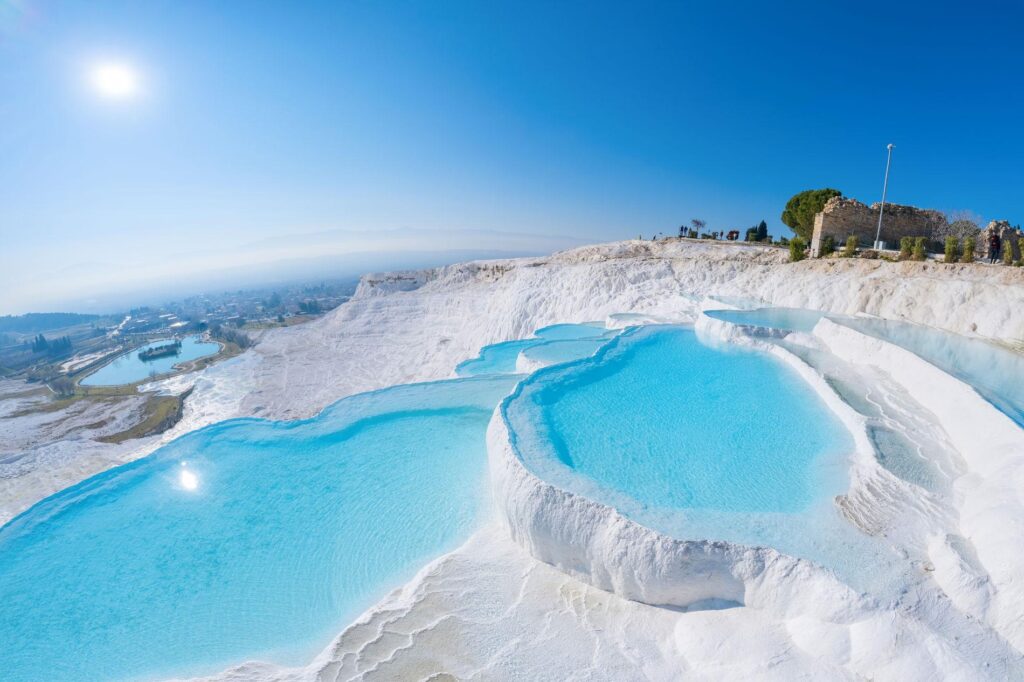
Hot springs have been flowing down this hillside for thousands of years, depositing calcium carbonate as they cool. Over time, terraced pools formed, carved out by the mineral buildup, filled with water that is a color of turquoise that really shouldn’t occur naturally. The Romans built an entire city at the top of it, Hierapolis, because they thought the water was medicinal.
Walking on it is something I didn’t expect to be so strange. You go barefoot because shoes damage the surface. The calcium is hard and rough, but in certain spots it gives slightly, almost like very stiff foam. The water in the pools is warm, not hot. And the whole thing is so white it’s almost painful to look at in direct sun.
The Part Most Visitors Miss
Pretty much everyone who visits Pamukkale spends most of their time taking photos in the lower terraces and then leaves. The Roman ruins of Hierapolis at the top get a fraction of the attention and they genuinely shouldn’t.
Wandering through a mostly ruined ancient city while looking down at the white terraces below, with the Turkish plains stretching out behind you, is one of those double-take moments that doesn’t photograph properly. It’s too wide and the depth doesn’t compress well. You have to be there with your own eyes.
Go early. This is consistent advice for almost everywhere on this list and it’s consistently ignored. By ten in the morning the tour buses start arriving and the lower pools become an exercise in patience. Before eight, you can have sections of it almost to yourself and the morning light on the calcium turns everything slightly golden rather than harsh white.
Wai-O-Tapu Thermal Wonderland, New Zealand
The name translates roughly to “sacred waters” and while I usually find that kind of naming a bit much, it’s actually appropriate here.
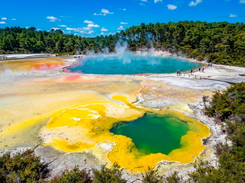
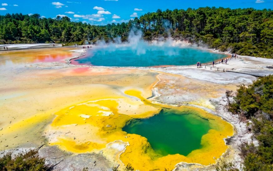
Wai-O-Tapu is in the Rotorua geothermal region on New Zealand’s North Island and it is one of the most visually chaotic landscapes I’ve ever read about from multiple travelers who describe the same thing: you walk around a corner and see a color that doesn’t belong. Then you walk around another corner and see something else that doesn’t belong. And this keeps happening until you’ve basically accepted that your understanding of what colors ground can be was wrong.
Boiling mud pools. Sulphur vents steaming in the cold air. And then the Champagne Pool, which is the centerpiece — a large thermal lake rimmed with a thick border of vivid orange where the minerals deposit as the water cools at the edge. The water in the center is greenish-blue. The edge is orange. There’s steam rising off everything. The whole scene looks digitally saturated even when you’re standing right in it.
The Geyser Situation and What to Do About It
Lady Knox Geyser is part of the same attraction and goes off at 10:15 every morning after staff members add soap powder to lower the surface tension and trigger the eruption. This draws a crowd of tour buses. If you’re going to Wai-O-Tapu, arrive when the gates open and do the thermal park first, then watch the geyser, rather than starting with the geyser and walking into the main park with everyone else.
Stay on the marked paths. This sounds like the kind of advice that’s included for legal reasons and that sensible people can ignore. It’s not. The ground in active geothermal areas is unstable in ways that are not visible. The pools are genuinely dangerous. People have ignored the signs at places like this and have been seriously injured. The paths are there because someone mapped where it’s safe to stand.
Zhangjiajie National Forest Park, China
The floating mountains in Avatar were not invented. They were based on this.
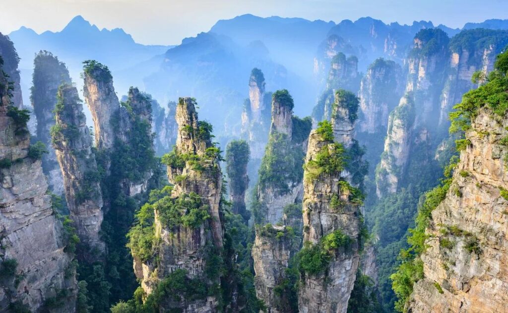
James Cameron’s team visited the area before production and the sandstone pillar formations in Zhangjiajie in Hunan Province are exactly what they used as the visual reference. Seeing the film after visiting, apparently, is a deeply strange experience — like watching a documentary about somewhere you’ve already been.
The pillars rise hundreds of meters straight up from the valley floor. They’re covered in vegetation, trees and moss growing on near-vertical surfaces. When there’s cloud or mist in the valley, and there often is, the tops of the pillars appear to float above the white below. Looking across from the higher viewpoints, you see maybe fifty or sixty of these pillars disappearing into cloud in every direction, and the scale genuinely doesn’t compute. Your brain keeps trying to find a reference point and there isn’t one.
Practical Notes on Visiting
The park is large and most people see a fraction of it. The most visited viewpoints are genuinely extraordinary but also genuinely crowded during Chinese national holidays. Spring and autumn are better for both weather and crowd levels. Summer can be humid and hazy in ways that reduce visibility.
The glass-bottomed walkway is famous and people have different reactions to it. Some find it thrilling. Others find it make them feel briefly like they might actually die, even though it’s completely safe. Worth doing but worth knowing that it feels more vertiginous than most things described as vertiginous.
Getting a Chinese SIM card or a data plan that works in China before you arrive is worth organizing. Google Maps is blocked without a VPN and Apple Maps works but inconsistently. Amap is what locals use and functions well, though it’s in Mandarin. Google Translate’s camera mode handles signs well enough to get around without Mandarin.
The Danakil Depression, Ethiopia
This is the one where I have to be honest with you upfront: it’s genuinely extreme and the fact that it’s on the same list as Turkish thermal pools is slightly misleading.
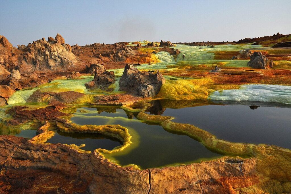
The Danakil Depression sits in northeastern Ethiopia, below sea level, and summer temperatures regularly hit 50 degrees Celsius. It holds the record for hottest inhabited place on Earth. The landscape features active lava lakes that glow red at night, acid pools in yellow and green, and salt formations that look like something that shouldn’t be able to exist in open air.
Afar salt miners still work the region, cutting salt blocks by hand and loading them onto camels, which adds a strange human element to an environment that otherwise feels completely uninhabitable.
What You’re Actually Signing Up For
Tours depart from Mekele in the Tigray region and require guides, permits, and armed escorts. The security situation in the Tigray region has been volatile and before planning anything, the first step is checking your government’s current travel advisory for that specific area. Not Ethiopia generally. That specific region.
The physical experience is multi-day camping in serious heat, with nights that are still warm. The sulphur smell is strong enough that some operators provide basic respirators for the most active venting areas. Water management is handled by your operator but you must follow their instructions on consumption.
People who do it often say it’s the most extraordinary landscape experience of their lives. People who do it underprepared often say something considerably less enthusiastic. It’s worth being honest with yourself about which kind of traveler you are before committing.
Fly Geyser, Nevada, USA
This one is unusual on this list because it doesn’t have a geological age story behind it. Fly Geyser was made by accident in 1964 when a geothermal energy company drilled a test well, found extremely hot water, and then abandoned the site without properly sealing it.
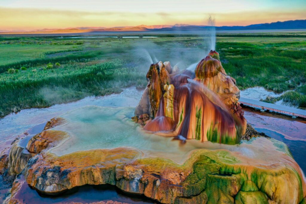
Over the following decades, minerals dissolved in the water built up around the opening, creating a layered, terraced formation about two meters high that continuously sprays water into a series of pools. The thermophilic algae that colonize the hot water surfaces produce bands of vivid red, green, and orange across the entire structure.
The result looks like something that fell off a spacecraft. A small, colorful, continuously erupting structure sitting in a flat Nevada desert with nothing around it.
How to Visit Without Issues
Fly Ranch, where the geyser sits, was purchased by the Burning Man Project in 2016. Tours are run through them and need to be booked in advance via the Black Rock Desert website. The property is about two hours north of Reno, on unpaved road for the last section, and four-wheel drive is recommended after any recent rain.
The tours are small group and genuinely unhurried, which is the right way to experience it. The guides explain the accidental geology and the whole thing, travel included, takes around half a day. It’s not a destination in itself for most people but fits well as part of a broader Nevada road trip.
Mistakes That Come Up Again and Again
Going in the wrong season is the most common one. Every place on this list looks significantly different depending on time of year, and not all the differences are obvious from photos. The Salar without water and the Salar with a thin reflective layer are two completely different experiences. Zhangjiajie in clear weather and in mist are both extraordinary but in completely different ways.

Trying to combine too many of these in one trip is something people regret more than they expect. Each of these landscapes takes time to actually absorb. Spending four hours somewhere that takes four days to properly process means you leave with photos but not the actual experience.
Underestimating physical demands is genuinely common. High altitude, extreme heat, long walks on uneven terrain without shade, multi-day camping in places without facilities. These aren’t just dramatic descriptions. They’re real conditions that require real preparation.
Treating the visit as primarily a photography opportunity and then feeling vaguely hollow afterward is something multiple travelers have described separately. The phone doesn’t go away in your pocket, but some intentional time spent just standing there, not documenting anything, tends to be where the memory actually forms.
A Few Tools Worth Having
Maps.me works offline and covers areas that Google Maps treats as blank space. Download the regional maps before you leave wifi. iOverlander is useful for very remote areas and has community-sourced waypoints from other travelers.
Weather apps with hourly forecasts matter more for landscape travel than city travel. Windy is particularly good for checking conditions at specific elevations.
Travel insurance that explicitly covers emergency evacuation is essential for the Danakil Depression and useful for high-altitude Bolivia. Read the specific wording on your policy. Adventure travel exclusions are common and discovering them in an emergency is extremely bad timing.
The Part That’s Difficult to Explain
There’s something that happens in places like these that I’ve heard described differently by different people but keeps pointing at the same underlying thing.
Rania said standing on the Salar felt like being slightly outside time. Someone else described the Danakil as the first place they’d ever been where their usual thoughts simply stopped. A friend who visited Zhangjiajie said he kept laughing for no particular reason, standing at viewpoints, just a completely involuntary laugh.
I think what’s happening is that these places are so different from everything your senses have been trained on that your usual internal monologue has nothing to hold onto. The to-do list, the background anxiety, the replay of yesterday’s conversation — all of that requires a familiar environment to project itself onto. Take away the familiar environment completely and the noise goes quiet.
That’s not a guaranteed thing. It doesn’t happen for everyone. Some people visit and feel nothing much beyond “that was impressive” and that’s completely fine too.
But for the people it does happen to, and there seem to be a lot of them, it’s the thing they talk about years later. Not the photos. Not the logistics. The specific feeling of standing somewhere that made their usual mental noise briefly shut up.
That seems worth a long-haul flight. Worth some altitude sickness medication and a sleeping bag rated for temperatures you’ve never needed before. Worth trusting a guide who doesn’t share your language and driving across terrain that doesn’t have roads.
Worth it, most people say, by quite a significant margin.